The Desert Speaks
Grand Canyon, The Human Touch
Season 15 Episode 1509 | 26m 20sVideo has Closed Captions
Host David Yetman joins his brother along the Colorado River and Grand Canyon.
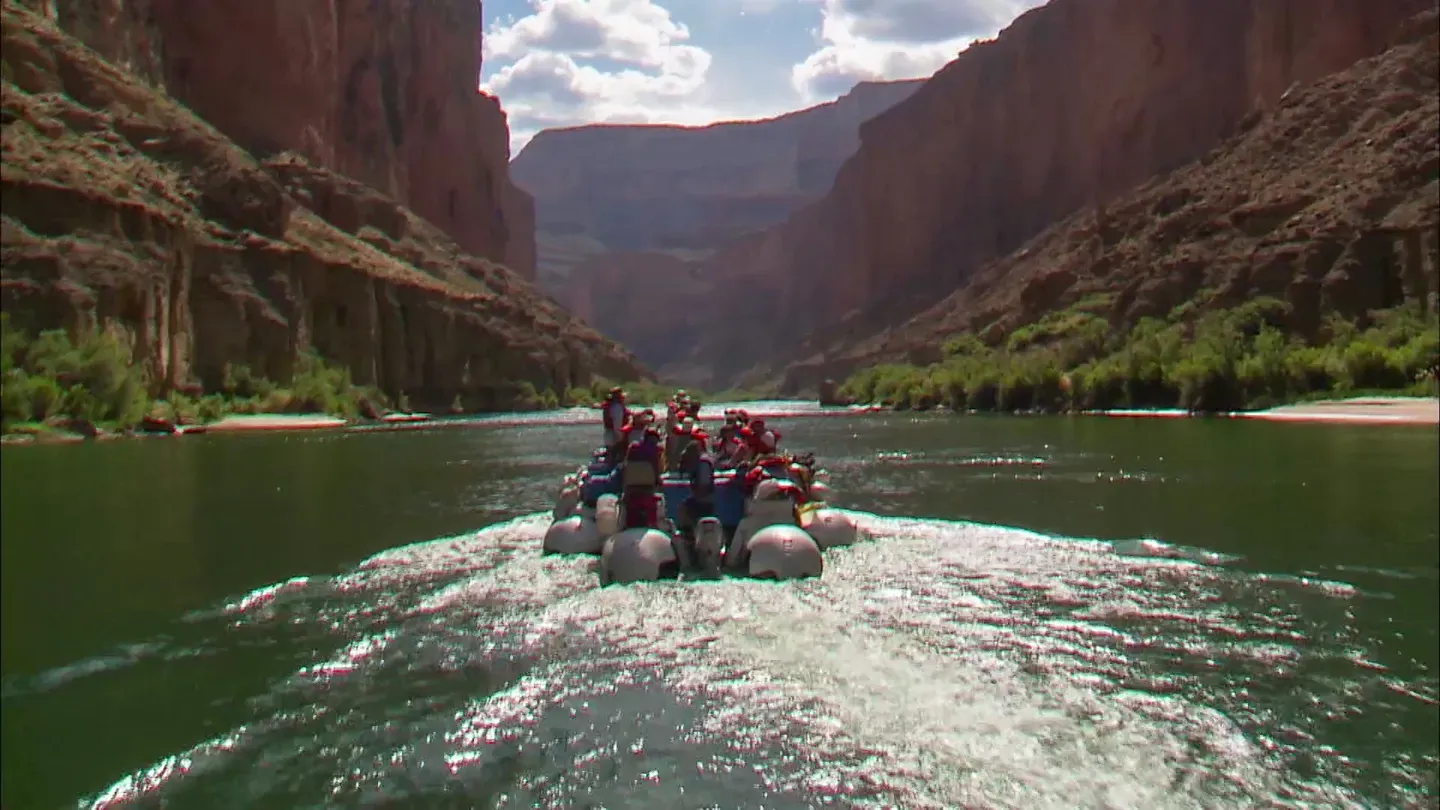
Host David Yetman joins his brother, geologist Dick Yetman, for an exploration of the traces of humans along the Colorado River and Grand Canyon region. They observe sacred salt mines from the boat, visit the intersection of the Little Colorado River with the main river, learn the history of rapids and spend time with scientists studying the effects of the Glen Canyon Dam.
The Desert Speaks is presented by your local public television station.
This AZPM Original Production streams here because of viewer donations. Make a gift now and support its creation and let us know what you love about it! Even more episodes are available to stream with AZPM Passport.
The Desert Speaks
Grand Canyon, The Human Touch
Season 15 Episode 1509 | 26m 20sVideo has Closed Captions
Host David Yetman joins his brother, geologist Dick Yetman, for an exploration of the traces of humans along the Colorado River and Grand Canyon region. They observe sacred salt mines from the boat, visit the intersection of the Little Colorado River with the main river, learn the history of rapids and spend time with scientists studying the effects of the Glen Canyon Dam.
How to Watch The Desert Speaks
The Desert Speaks is available to stream on pbs.org and the free PBS App, available on iPhone, Apple TV, Android TV, Android smartphones, Amazon Fire TV, Amazon Fire Tablet, Roku, Samsung Smart TV, and Vizio.
Providing Support for PBS.org
Learn Moreabout PBS online sponsorshipThe Grand Canyon region is known as one of the greatest natural wonders of the world.
But a journey along the Colorado River reveals the human side that has existed there for thousands of years.
This is the view the people come down the canyon to see, all the way from the North Rim.
Funding for the Desert Speaks was provided by Desert Program Partners.
Representing concerned viewers making a financial commitment to the education about and preservation of deserts.
And by The Stonewall Foundation.
A crease on the face of the earth, one of the seven wonders of the natural world, has drawn people to its depths for millennia.
They come to the Grand Canyon for ceremonies, for inspiration, for adventure and to manipulate its waters for the development of the west.
They all leave their mark for better or for worse along the course of the Colorado River.
The Colorado River makes a huge gash in the Colorado Plateau.
It's a land of numerous monuments and canyons like that of the Little Colorado River.
One person who knows the region well and can show us part of the rich cultural history is my brother, Dick Yetman.
He'll take me to a few important stops before we get our feet wet.
This gives every appearance of a community bulletin board.
Yeah, it kind of gives you can idea of just how many people must have gone through this area at one time.
And leaving each their own individual symbol.
Well, a lot of people must have passed through here from going to one place to the other.
Yeah, you know, it was my impression that this was in route to the salt trail in the Little Colorado River Valley.
Down in the bottom of the canyon?
Down in the bottom of the canyon.
Hey, Dick, when did you first find out about this place?
About 20 years ago a friend of mine showed me this spot.
You didn't tell me.
You didn't need to know.
Well, maybe it was cause I didn't ask you.
Is it well known?
Well, I think it's a word of mouth thing.
I didn't realize how significant it was initially.
Boy, it's got hundreds and hundreds of pieces of rock art here.
You have to wonder if this was graffiti in those days.
It certainly isn't now, is it?
You can't distinguish between what they were playing with and what they were serious about.
From the rock art a serious walk of a day or two takes us to the brink of Marble Canyon.
Oh, wow, the river looks so tame from up here.
Looks pretty gentle.
Doesn't look very cold, either.
Yeah, well, my understanding is it's about 42 degrees.
That's cold.
It's a true horseshoe, a gooseneck.
An ox bow to be.
Someday.
Upstream from the canyon called Marble is Glen Canyon.
Once described as the most intimate of the Colorado Plateau.
Now it is greatly altered.
The primary purpose of Glen Canyon Dam is actually for the storage of water, irrigation water for delivery down to the lower basin states and it also assures the upper basin states that they can use their allotment of water.
Lake Powell is currently about 117 feet down from normal full pool.
We're in about the fifth year of a drought cycle.
Well, currently there is no impact to power generation.
We're still able to meet our full power requirements as identified by western power administration.
We still have about a hundred foot above what we call our minimum power pool.
So we're still in pretty good shape there.
If this drought continues though, it will take us, force us to take a look at how we do business and reconsider how we release water out of Glen Canyon.
This dam is doing exactly what it was designed to do, to store that water in good years and getting prepared for those bad years.
15 miles downstream from the dam is a traditional place to launch a trip on the river.
It's called Lee's Ferry, an ancient crossing now used by river companies and fishermen.
Here we meet the rest of our river running friends.
So are you guys ready to do some of this?
Let's do it.
All right.
The most important thing on these trips is safety.
And the safest thing you can do is when you're on river is wearing these things here.
9 So if you fall in that river without one of these on, you will get sucked down and you will not come back up.
That's enough of a shock to make you want to wear a good secure life jacket.
And we get to name them, they're brand new.
Elves Chasm.
Try Monument Valley.
I wanted Vermillion but it was taken.
Whirlpool is going to be the name.
We're going to be on a river full of whirlpools.
There's a lot of whirlpools, that's why you have to wear your life jacket.
Once I get in my life jacket, which I have now one for eight straight days.
Over to the right here is the original Marble Canyon bridge.
It was a great thing when that bridge was put in because people could get to the north side of the river now without having to go to Lee's Ferry.
A few years ago, when the North American Free Trade Agreement was passed, this new bridge was put in about the same time in anticipation of a lot more commerce coming from the southern part of the country to the north.
It's a much bigger bridge and handles a lot more traffic.
Still, there's a 250 mile gap in which you can't take an automobile across unless you want a ferry with a helicopter.
I guess that's what makes Grand Canyon National Park.
The different strata or layers of rock are obvious to geologists like Dick and to lay people as well.
A different perspective comes from those who have crossed them on foot.
What is about the Supai that makes it so great for hiking?
Well, if you look at the different gradations in here, you can see some areas are quite resistant to erosion and some areas aren't.
And these softer areas erode away leaving these little cliffs.
Oh, so it makes just a nice progression of stairways, huh?
Perfect stair steps.
Great.
When you think of the thousands or tens of thousands of small canyons like this throughout the Grand Canyon National Park, many of which have probably never even been touched in certain areas just because.
Well, probably some of them were completely inaccessible.
They have their own character basically because of the composition of each one.
Even if, for example, the Coconino sandstone and the Supai sandstone are both sandstones.
They're very different.
The Coconino is a lot more of the cross bedded dune type formation where the Supai perhaps is more of a deposition in a shallow sea.
We've probably gone through 150 to 200 million years today in the 17 river miles that we've covered today.
But that's speculation of course.
The Roaring 20s, the first big stretch of constant white water on the Colorado River in Grand Canyon.
To get a place named after you now, you have to do something extremely stupid.
In the old days, when none of these rapids were named, all you had to do was flip and die basically and you got your name on it.
You can see that rock way down on the left, the current's going to try to slam us in there.
Too many people were just flipping and dying and they couldn't name it after all these people so now it takes something extremely unique or stupid to get a rapid named after you.
Or being a very historical person.
Named on one of the first expeditions through the canyon, Sockdolager was a slang term in the late 1800s for a one-two knock out punch.
And it is said that one of the first trips to run it, the boatman exclaimed at the bottom, "Ooo-eee, that was a real sockdolager," and the name stuck.
[screaming] I know, I tried to protect them all.
I hid behind her but it didn't work.
Well, there are some rapids that are more rapid than others and the rapids refers to the speed at which the water hits you in the face.
[screaming] Vasey's Paradise was named by John Wesley Powell and his crew on their first trip through here in 1869 and they realized it was just the most beautiful waterfall that they had ever seen.
Powell stopped and looked at it and the botanical display there is so incredible, dozens of different types of plants, maiden hair ferns and monkey flowers and all sorts of wonderful stuff, that he decided that his buddy George Vasey, who was a botanist who was not on the trip, would have loved the place and he named it in honor of his friend George Vasey, Vasey's Paradise.
John Wesley Powell named Red Wall Cavern on his first trip through here also.
We know that he stopped to camp there.
It was monsoon season and it was raining and they had lost all their bedding and blankets by this time on the trip.
They were so happy to find this big overhang.
[music] One of the things Powell said about Red Wall Cavern is, "This would be a great place for a concert."
And he was right.
The acoustics in there are fantastic.
[music] Over the years it's become traditional for certain river trips that have musicians to stop and play there.
[music] Here rapids are shorter and there's flat water above and below.
This is called the Pool and Drop River.
We are in one of the pools.
Notice how our current has slowed down tremendously here.
Just downstream you can hear a rapid.
There's a side canyon at that rapid, which has flushed debris in causing a dam across the river, a natural rock dam.
The water's pooled up behind it.
Come on, we're going to get a little bit wet.
All right, this is a big hole, Yetman, we're going to get zonked, we're going to get schmonked.
Yeah, Georgie's Rapid has not had the advantage of having huge floods from the Colorado come through to move the boulders downstream and make it easier to run.
And this is because Glen Canyon Dam is up there stopping the big floods from coming through.
So Georgie's Rapid is going to be a pretty sharp drop right at the top.
So I want you to have two really, really, really good handholds.
We're at low water today and so the first drop could be quite steep and the first wave could be quite a hard hit.
We may make it through and then we may not make it through.
Odds are pretty good, somebody's going to get wet.
[screaming] This is really quite cool, you know.
I see you as a little stressful.
You are so light I thought we were going to lose you for a minute.
I have more padding than you do.
The impact of Glen Canyon Dam has been that the river instead of eroding in its normal cycle now is down to a steady ebb and flow cycle.
Instead of getting periodic flash flooding which scours the canyon, moves the beaches, changes the rapids, it's very rare that that happens.
The only time that it happens now is if we get a great flood down the Little Colorado River and that hasn't happened for a long time.
The water is clear now where it most be muddy most of the time and particularly in flood stage the water was, they used to say too thin to plow, to thick to drink.
The Dam altered not just the amount of silt in the water but also its temperature and the water levels, especially high flows.
Those manipulated fluctuations have changed the plants and animals that live near the river and have brought on the need for more investigation.
We're monitoring arthropod biodiversity, species richness.
This is all within effects of the Glen Canyon Dam operation.
So we're just monitoring how the dam operations are affecting the three different zones.
Insects, they're so abundant, they have fast metabolism so they can go through several generations and they make a great indicator species of environmental changes, how the environment impacts them and insects and plants.
You know, they're at the bottom of the list and everything feeds on them.
So you start with the plants, arthropods, then go to higher vertebrates.
Trying to collect data on the herps, bugs, mammals, veg and birds at the same sites to see if we can tease out any patterns of diversity in abundance, community structure related to dam operations.
And what I'm seeing is this new vegetation does support a dense herpertefauna, certainly not that diverse compared to other southwestern systems because it's a long linear corridor but I think the new vegetation that's come in after impoundment of the reservoir has created a more abundant food supply for the lizards.
The lizard on the top here, the larger one's a female spiny lizard.
In the canyon they like living on boulders in the old high water zone.
You'll often see them up there basking and displaying.
The lower lizard, the smaller, is a male tree lizard.
And tree lizards thrive on vertical surfaces.
This is how we sweep the vegetation for insects that live on the foliage.
We have the various traps that we use and we also wander around and capture insects that don't fall into our trapping devices.
In fact a lot of the unusual species we get are through general collecting.
The boats called dories are still rode down the Grand Canyon.
They have the advantage of having Lake Powell above with its Glen Canyon Dam.
John Wesley Powell, who came down here in a wooden boat similar to these, had not such advantage.
He never knew from one day to the next how much water would be in that river.
[screaming] In the early 1960s, the steep walls and narrow gorge bottom of Marble Canyon attracted the attention of Western Water and Power Interest who proposed to build a dam at this spot calling it Marble Canyon Dam.
I was a young graduate student at the time and witnessed a most furious battle over a public works project in the history of the United States.
The environmentalists, led by the Sierra Club, won and today the Colorado River in Marble Canyon still runs free.
One of the supposedly selling points, and it's hard to believe, the selling points of going down on these trips is the privilege of sitting where we're sitting and getting wet.
If you can imagine people pay good money to get cold water splashed in their face?
And can you imagine people deny themselves this opportunity?
That's great.
Well, anyway the price is right.
I see a glimpse of sand and sunlight that may dry us out.
At River Mile 52 a side canyon named Nankoweap created enough land for ancient peoples to farm.
Any surplus was stored in special places in canyon walls.
Hey, look, Dick, do you really think that Indian women had to come all the way up here to just pick up an oya of corn?
That just sounds like all manner of fun.
What do you think they thought when somebody said, "Go get the corn."
Did they go, "Rats!"
or did they go, "Yeah, I want to go up there."
Hey, you forgot the corn, honey.
That's a long way to climb to store grain.
Yeah, but they were above flood level.
Yeah, well, I suppose so.
That was before the dam didn't break.
Do you see these sights all over when you're hiking?
Cause I've only done three or four trails and I've never seen anything like this.
Well, I wouldn't say all over but there's certainly a lot of places around here where you find them.
Oh, my goodness gracious.
Well, that's worth looking at.
This is the grainary view.
Well, no wonder they built it up here.
This is the view that people come down the canyon to see.
All the way from the North Rim.
All the way from Lee's Ferry.
I think the path deteriorated here.
No, it just gets a little sketchy.
Come on, Dick, don't get so far behind.
You know, if you'd stay in shape you could make it up here.
Hey, at least I'm in second place.
Yeah, well, I'm next to last.
Ah, the grainary.
Boy, that's a long way.
Are we at the contact place here between different rock layers?
Is that why they put it here?
You know, it looks like this is the contact between the red wall and the Muav limestone.
What a great place for a little grotto.
Oh, there it is.
You know, I take back all the facetious things I said.
That's good work and it was hard work.
But you know I get the feeling they were working with limited materials up here.
Oh, god, the stuff they have to bring up.
Do you suppose they had to finish any of that stone.
It fits so well.
They couldn't have just picked up stuff anywhere, they had to bring that up from down below.
Well, once again, I think the urine theory may still hold out.
Yeah, I think that's correct.
Yeah.
But you know when you think that the red could have come from the hermit shale all the way down, all the layers all the way down and stained this.
Because look it, those rock faces, they would have been Muav colored at this point.
That's right.
In order words, they put the rocks in and since that time, 800 years or so ago, they've taken on the color of the hermit shale, which is what, a thousand feet above us.
Was that your idea?
That's a great idea.
I'm good at painting.
Had I been here I'd have told them, "Guys, just leave it and over the centuries it'll turn this beautiful pink."
I've got to travel with you again, David, you come up with the most incredible ideas.
You should.
You should.
You'd really learn a lot.
Well, I admire the grainary but it's kind of hot up here so it's time to destroy our knees and walk back down.
Well, you know, just to admire this I think I'll continue to walk backwards downhill.
That way it won't hurt as much.
Well, get out of the way so I can get by you, save my knees.
This is very sacred land to the Hopis.
For elders to come down and collect sacred salt.
It was a pilgrimage route for boys in their passage into manhood.
Boys would come down with a sacred artifact such as a prayer feather or a sacred prayer stick and that would be deposited in the mine and then he would take one that had been left by a previous boy that had been encrusted with salt to return back to the mesas to prove that he had made it all that way.
Up the Little Colorado is a place called Sipapu or Sipapuni, which is a travertine dome with blue water springs emerging.
And that is in Hopi beliefs their place of emergence from the third world into this world, the fourth world.
You know, Dick, from the top of the gorge of the Little Colorado looking down you'd never thought there'd be this kind of eerie blue water.
Well, I'm not sure this is the same river.
I think I ought to walk it out to find out.
It's completely different from the Colorado.
It's also a lot warmer.
Well, I think the big impact of the Glen Canyon Dam is the cold water now mixing with the blue waters of this has really changed the habitat for the native fishes that live in here.
So it used to be right at the confluence this weird mixing of water that created this special habitat.
Right.
It's something that's for eons they've been able to handle.
Yeah.
I think I'll just cool off a little bit.
Oooh.
I wouldn't want to drink it.
It tastes minerally.
A little maybe vaguely salty and minerally.
And I think it's not the kind of water you want to drink.
Maybe you do.
It's not the kind of water I want to drink a lot of.
I've had worse.
Well, that's an important place for fish but it's also been historically for eons really a sacred place for some indigenous people and the eerie feel of it tells me that they were on to something.
They were on to something but why isn't there a group living in here at this time I wonder.
Well, you know I suspect that they couldn't live on that water.
It probably is not of drinking quality.
So they'd have to bring all their water from down in the Colorado and that would often be muddy.
[music] The dams created on the Colorado River in the last century have turned the Grand Canyon into a more or less efficiently operating hydraulic system.
But over the eons nature has created dams also and the raw power of water has torn them away.
In the future, we can be sure that nature will once again triumph.
Next time on the Desert Speaks.
You can experience geological mastery of the Grand Canyon from the air or by land.
But to get the most intense sensory experience it's best on or actually in the water, down the Colorado River.
During the summer this river would have been flowing 80 to 90 degrees from being heated in the desert sun, coming all the way down through Utah.
In the wintertime it would have been colder, icebergs flowing down it.
They said a couple of years it even froze over at Lee's Ferry.
Now of course because of Glen Canyon Dam the water's being brought from way under the surface where it hasn't seen sunlight.
45 degrees at Lee's Ferry.
Funding for the Desert Speaks was provided by Desert Program Partners.
Representing concerned viewers making a financial commitment to the education about and preservation of deserts.


The Desert Speaks is presented by your local public television station.
This AZPM Original Production streams here because of viewer donations. Make a gift now and support its creation and let us know what you love about it! Even more episodes are available to stream with AZPM Passport.